Oct 9. Lapubesi to Dobhan (Tatopani). Manaslu trek, Nepal.
We shortened our trip leg to Lapubesi because one of the party was suffering
from the heat. The valley narrows and in places is very steep. There are hot
water springs at Tatopani.

Google maps and the Flickr maps are fantastic. If you click on the
link Lapubesi to Dobhan it will take you to a map with pink dots laid on the map locations.
Click on the dot and the photo gets displayed. Click on the photo and a
big image gets produced. I have set the map to map mode, but there is
also hybrid and satellite modes to show the terrain image from up above.
Zooming in and out can give an overall or micro perspective. I used
Google maps to plan the trip and Flickr bundles it to allow you to map an
album, also Google Picasa does a similar thing but only offers 5 gig compared
to a terabyte offering by Flickr (Yahoo).
Walter was suffering a bit from the heat and cramped overnight. We elected not
to go all the way to Dohan and shorten the journey to Tatopani. The day was
hot and humid again so the decision was wise and really would of only cut an
couple of hours of the intended destination; early in the walk this is easily
recaptured.
We saw the girl that was swimming with me in the morning waving cheerfully.
She was local, the walk we do and think is long is something of a daily
activity here. The others were laughing and it was a little while before I was
made aware of the reason. You know the old saying "he wouldn't know a pass if
it hit him in the face" - well that is me. Last night in front of my cabin
there was a string line, on it was one item of clothing, a wet sarong. Anyway
as I pegged my clothes on the line to dry I stretched it out as I said it
would dry properly being so crunched up. Rajesh said it probably belonged to
cabin 4 as they had to reshuffle to allow us to stay so he moved it.
Apparently by straightening it out was an invitation for the lady to come in,
there you are - educated !
The rural life. Animals are kept close by the house and there is always work to do with grain threshing, collection of firewood and so on. We witness to that throughout the day. The houses are simple two story construction using whatever material that is to hand.
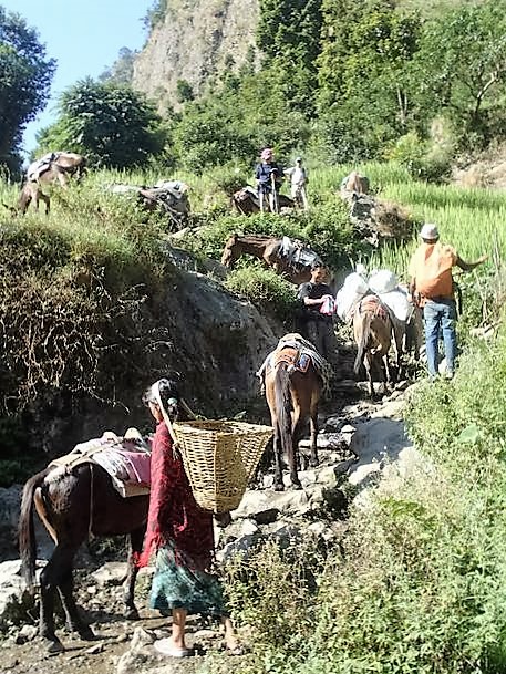
We often reach animal caravans and porters, the only way to move goods in this valley other than helicopter perhaps. Unlike the Annapurna circuit there is no vehicular road. Good for us tourists, it is quite a spectacle with brightly coloured weavings on the animals, and the hubbub of bells rattling and the noise of the handlers issuing commands to proceed. On suspension bridges we wait for the animals to cross as the always take priority.
The water was enticing. We stopped and enjoyed a pool. Chilly, but a refreshing, the swim was just what we needed after a few hours of walking.
After the swim we stopped at a 'roadside' stall set up in the river valley for a snack of boiled eggs and tea.
There were quite a few locals with their pack animals also resting.
Beer o'clock. On these hot days at low altitudes, there is nothing like a cold - well almost cold - beer. At lunch or the end of the day, a beer is well received. My personal rule is not to drink over 2500 metres to avoid altitude sickness. Ginger tea is fast becoming our favourite non alcoholic beverage, ginger being supposedly good for the stomach.
Anytime it was getting too hot, there would soon be a reprieve available with some chilly flowing water.
Tatopani was a very small village squeezed beside the river. It has hot springs that provide a warm place to wash. (tatopani = hot spring)
Our accommodation was in the roof with very low ceiling height, not good for us Westerners. I banged my head several times forgetting the ceiling height and door entry heights.
It got dark quickly here, so there was a mad scramble to find head torches.
The town just before Tatopani (Khorlak ?) , where we dipped our
feet probably offered better accommodation in a more aesthetic setting.
Contents
Navigate


Comments
Post a Comment